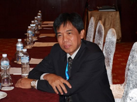
Interview with Mr. Agus Hidayat, Director of the Remote Sensing Application Center, National Institute of Aeronautics and Space (LAPAN), at APRSAF-19 in Kuala Lumpur (Dec 2012)
<Part 2>
Continued from part 1
S: Today, during your presentation at EO WG, you mentioned that LAPAN would raise the rice crop and conduct research on paddy fields and droughts. I think that Indonesia is benefiting from space activities within the country as well as through international relations.

Yes. As I mentioned in my presentation, we have meetings at least three times a year with the user agencies, the Statistical Bureau, and the Ministry of Agriculture. The Statistical Bureau provides data and the Ministry of Agriculture provides practical data in the field to deal with rice availability. At the meetings, we are trying to quantify the amount of rice production this year, and to understand whether rice would need to be imported or we have enough rice to harvest.
So, space-based information is really useful for an agricultural country like Indonesia. Rice is very important for us. We are among the world’s top 10 importers currently because we eat more rice. Most of the rice is coming from Java. While more people are moving to Java, land is being converted from paddy areas to other uses. That is why there has been a shortage of rice. Because of this, LAPAN is trying very hard to help the government to monitor or to map the existing paddy field, and to make sure that it does not decrease. Our role is to recommend to the government which area is good for opening new rice fields. We are trying to help the government in terms of agriculture and food security.
S: In that sense, I think LAPAN is a good example for the other Asian countries to make use of space applications.
You can say that. We are not doing research for research alone. We are trying to implement the research results in the field.
S: Some Asian countries are just beginning to use the remote sensing data for their governmental activities or private activities. Will your report be very beneficial to those countries?
I hope, it will. We are open to collaborate with any other Asian countries, similar to what we did a few months ago. There was an exchange of knowledge and methodology with the Malaysian Remote Sensing Agency (ARSM). They came to our office to learn how to use the remote sensing data to predict the fishing grounds. We learnt from them how they were able to do the same in Malaysia. We shared our knowledge. We would like to learn from other countries about their best practice in using space-based information for any kind of application.
S: Speaking of application, SAFE activity covers a very wide range—coastal protection, fishery, drought, etc.
Yes, and one condition in a SAFE prototyping project must be implemented by other users, which is the most important factor. The SAFE project is bridging the gap between the research agency and the user agency. That is very important. Otherwise, research would be for research only and nothing would be implemented in the field.
S: What is your opinion about APRSAF?
I think APRSAF is an international initiative that does a lot of important and useful work. It is not a legally binding organization, but a very flexible organization. However, we have actual projects and we put the results into action. For example, we have Sentinel Asia and SAFE, and these initiatives bring the research agency and the user agency together; otherwise, these agencies would have never met. I think if we can maintain the way these initiatives have been operated, on a voluntary basis, it is very good for the members.

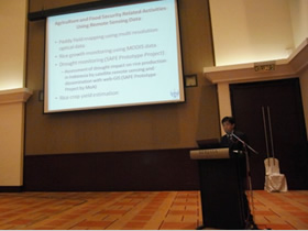
Mr. Hidayat presenting at EO WG
S: That point was discussed in EO WG.
I support the idea of keeping it the way it is. Not too formal. Let's keep it flexible, like the current one. I think it is very easy for us to join these activities without any additional burden. But of course, we need to take care of this organization together, and we need to contribute more for the continuation of this unity and this community.
S: Apart from APRSAF, regarding LAPAN's satellite plan LAPAN-A2, A3, and A4, I have the impression that LAPAN has seen good stable progress. You had started with LAPAN TUBSAT and you are making steady steps toward your own satellite. I think in the near future, you will contribute to the APRSAF community through them.
Yes, our program is to master how to develop our own operational satellite step by step, because if we just buy the large satellite, which we can, we would have very limited transfer of knowledge about how to build our own satellite. I think that is LAPAN's policy right now. Then, once we are ready to build an operational satellite, of course, we would need to collaborate with foreign manufacturers or other entities.
S: Thank you.