

SAFESpace Applications For Environment
![]()
For up-to-date information about the SAFE initiative, please visit the SAFE Portal site.
Objectives
Space Applications for Environment (SAFE) initiative was formulated targeting environmental monitoring from local scale to regional, and finally to global scale as a voluntary framework. The initiative explores the use of space data to monitor and address climate change impacts as well as study other forms of environment related issues to bring-in practical solutions contributing to global agendas including the UN SDGs, the Paris Agreement and the Sendai Framework for Disaster Risk Reduction. SAFE is designed to make use of various data and information including satellite based remote sensing, satellite navigation, ground based information and ICT to contribute to the realization of sustainable and secure society in the region through the support of space agencies, user agencies, academia, regional/international agencies, and the industry.
Background
Livelihood of people in the Asia-pacific region is always challenged by various natural disasters, mostly due to extreme climate events. Changes in the global climate intensify climate hazards, amplifying the risk on societies, and these risks further escalate with improper management of the fragile environment. Having acquired a vast amount of satellite data since the launch of Earth observation satellites, studies and research have shown the benefit of satellite observation in understanding environmental changes and climate change related issues, as well as in monitoring earth’s environment from local to global levels effectively and objectively. The use of space technology (specifically Earth observation satellites) enables global and long-term monitoring of environmental changes. Establishing an initiative focusing on the use of space technology in environmental monitoring has been a topic that received attention in number of APRSAF meetings, and the SAFE initiative was launched in 2008 at APRSAF-15, held in Hanoi, Vietnam.
Framework of SAFE
Since its inception as an initiative of APRSAF, SAFE prototyping activities were conducted in a bilateral manner between an individual country/agency and a space agency. This structure continued until 2018, having successfully completed 27 prototyping activities. Recognizing the benefit of multilateral cooperation where more resources and knowledge can be brought together, the SAFE implementing structure was renewed to become “multilateral” allowing more organizations to pool resources and work together. With this change, new proposal could be developed to demonstrate and implement multilateral collaboration using results from completed SAFE Prototyping and/or ongoing other projects of Implementing Agencies. New SAFE Projects are designed, proposed, and implemented by a team including a Project Leader and a Project Coordinator. The project activities are coordinated, monitored, and evaluated by the SAFE Secretariat with the support of SAFE Executive Board.
Activities
- SAFE was officially established at APRSAF-15 held in Hanoi, Vietnam (December 2008)
- As of March 2020, there have been 27 prototyping completed since the launch of SAFE in 2008.
- During APRAF-25 held in Singapore, the bilateral implementing structure of SAFE was changed to “multilateral projects” allowing multilateral collaboration with space agencies, research institutions, and international organizations in the Asia-Pacific region.
- The Agromet project was initiated and implemented as a SAFE multilateral project in 2018. This activity aims to develop a mechanism and a system to share agrometeorological information to help the region, particularly to improve agriculture information services in the region.
- In 2018, the Rice Crop Monitoring Project was also launched as a multilateral project to assist the region with food security.
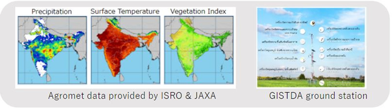
Agrometeorological data comparison study (SAFE Agromet Project)